
The Villages
 Phippsburg is almost an island, connected to the mainland by a causeway at the entrance to the town on the north side at Winnegance. The peninsula of Phippsburg is situated between the Kennebec River to the east and the New Meadows River and Casco Bay to the west. Phippsburg is about 12.5 miles in length and an average of about 3 miles wide. Many bays, inlets, coves, and marshlands surround her shores.
Separating Phippsburg from Bath and West Bath to the north is the narrow causeway at Winnegance with the Kennebec River to the east and Winnegance Creek to the west. The Winnegance Carrying Place was once where Indians carried their canoes across the 200 rod wide neck of land to enter the New Meadows River and continue southward to Casco Bay.
South of Winnegance and off a road leading eastward is the Fiddler’s Reach area. At the end of this road is a public boat launch popular during the summer. There is a walking trail at Noble Hill located near the tip of Fiddler's Reach. Also turning east off the Fiddler's Reach Road onto the Atwood Road will take you to a trail at the Greenleaf and Sargent 19 acre easements.
Continuing south on Route 209 is Drumore (with Drumore Bay visible to the east from the main road). The Stonybrook Road goes to the west near the big brick house. About a mile and to your left look for the Devil's Highway Road which leads to Bijhouwer Forest. This is a walking easement to 73 acres of beautiful forested woodlands with rare mountain laurels and a lovely trail.
South of Drumore is Phippsburg Center. The Center area has been the hub of the community for many years. The local fishermen and townspeople still gather at the Center Store early mornings (they open at 6:00 a.m.) for coffee and donuts before heading out to tend their traps, try their luck at tuna fishing, or heading out to work at the Bath Iron Works or other day’s events.
Just south of the Center Store lies the Center Pond to the east. This is a popular recreation spot for ice fishing in winter and canoeing and kayaking in summer. The 253-acre Center Pond Preserve is located on the eastern side of the Center Pond. This area is a rich, unspoiled area owned by the town and including a developed nature trail, with signs, and free parking. To access the Cooley Reserve take the Parker Head Road across from the Center Store. Parking is to the right just past the pond about halfway up the hill.
South of the Center Pond is the Phippsburg Elementary School to the west and Phippsburg Town Hall and Volunteer Fire Department to the east.
Just a few miles south of the school is the Sam Day Hill Road to the east. Just beyond this road is access to Sprague Pond with 110 acres of protected lands surrounding it. Look for signs near the parking area.
The 46-acre Ridgewell Preserve is on the east side of Route 209 just south of Sprague Pond Parking lot. Take the Robert E. Ridgewell Jr. Memorial Trail up a hillside to a pitch pine forest and onto 200 acres of additional protected lands that are owned by the town.
The Ashdale area lies several miles south of the school where Route 217 west branches right from Route 209 south.
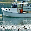
Turning onto Route 217 west and taking the first left will lead one down the West Point Road to the old fishing village of West Point. Many descendents of the original founding families still live in here and can be seen tending their lobster traps in the waters at the mouth of the New Meadows River, off the tip of Small Point and West Point, and out into Casco Bay.
Visiting artists et up their easels along the "loop" (Wallace Circle) at the end of the West Point Road painting scenes of this picturesque community with its beautiful vistas of granite ledges strewn with pines and open views to Casco Bay.
This is a working fishing village with commercial wharves both at the end of the road at Wallace Circle and another at the end of the Carrying Place Road (to the right just before "the loop." This is where the fishermen (and women) still bring in their day’s catch of lobster, crab, cod, tuna, and other fine delicacies from the sea to be sold and shipped to markets in Portland and beyond. During the most recent heyday of hook and line fishing for giant blue fin tuna in the early and mid 1990’s the wharf at the Carrying Place was packed during tuna season with fishermen, buyers, and tourists attending the live auctioning of the fish. This is also a great place to buy the live lobster, fresh and snapping, and maybe even to meet the fisherman that caught them.
Continuing on Route 217 west beyond the West Point Road leads to Sebasco.
The Sebasco Harbor Resort and Golf Course is on the left with spectacular views of Casco Bay. The history of the resort spans 77 years in Phippsburg. Originally owned by the Merritt family and part of Rock Gardens Inn, it was built between 1909 and 1912. Nathanial (Nate) Cushman bought the northern side of the property from Merritt in 1928 and built up what was known as Sebasco Lodge until 1997 when the present owner, Bob Smith, bought the property.
Nate Cushman was a very hard working and industrious man. My great aunt worked for him for many, years and had much respect and admiration for him. She told me that Mr. Cushman was a very non pretentious man who often wore overalls when he was working. One afternoon a guest arrived at the lodge and hopped out of his car. Upon seeing Mr. Cushman nearby (in his overalls), and mistaking him for a worker, the guest told Cushman to “get over here and fetch these suitcases for me.” Mr. Cushman never said a word, helping the man with his suitcases and mischiefously accepting a tip. Apparently the guest was quite surprised later that evening when he was introduced to the lodge owner (now dressed neatly in a suit and tie) at dinner and realized the mistake he had made. Mr. Cushman also built the salt-water swimming pool at the resort which is still used today. His four sons all became successful businessmen and many of his descendents still have homes in Phippsburg.
On the northen edge of the resort lies Cornelius Pond (now called Watah Lake). There was once a thriving ice business here and ice was cut and loaded onto ships for export to southern ports.
Across from the resort to the west is Harbor Island, once called Horse Island. This is where the horses from the ice cutting business were kept in the off season.
Continuing on Route 217 West is the Sebasco Post Office on the right and then the old village of Sebasco. Only a few original houses remain and are distinguishable by their cedar shingle siding.
Continuing on just a short distance and turning left at Black’s Landing Road will lead to the Water’s Edge Restaurant at the old Sebasco Downeaster Seafood location. The views from here are unbeatable. Malago Island lies to the west and the islands and open ocean of Casco Bay to the south.
The Basin area lies on the west side of town between Sebasco and Phippsburg Center but is not easily accessible by car. The road is dirt and potholed and the area is privately owned. The best way to see the Basin is by boat - up the New Meadows River and into its entrance. A nautical chart is recommended as there are many shoals and rocks along the way often hidden by the tide which can fluctuate by as much as 12’ at times.
Coming back out of Black's Landing Road, turn right, past the village, the post office, the resort, and back out to where the road connects with 209. Turn right here, and continue down 209 south.
Continue along Route 209 South until the road branches to the right. Do not turn here, but continue straight (the road now turns into Route 216) and this will lead to Small Point.
Along the way to the east is the Bate’s College Morse’s Mountain Preserve. Turn up this road and there is a parking area. The preserve has two trails. One trail is quite a hike and leads to a beach. The other trail is shorter, but steeper, and goes to the top of Morse’s Mountain. Breathtaking views of Seguin Island and lighthouse, the Sprague, Morse’s and Kennebec Rivers, Casco Bay, the old Salt Marshes of Small Point and much of the southern end of town can be seen from here. Bring a camara!
Continuing along Route 216 almost to the end, one finds the Hermit Island Campground. There is a small entrance fee to park and use the spectacular large beach here but it is well worth it as the views are unobstructed to the south out to Casco Bay.
Nearby Webber’s Island is where artist John Marin had a summer home around the turn of the century and painted many of his famous works.
The Hermit Island property has been in the Sewall family for many years and is still pristine and full of wildlife. White tailed deer are seen on the island, soft shell clams can be found (and steamed over campfires), tidal pools are full of fascinating creatures from the sea, and it is a lovely place for a day trip or vacation.
Going back up Route 216 and turning right where Route 209 south and 216 branched off, take Route 209 south toward Popham Beach. This road makes a sharp 90 degree turn to the right at the bottom of the hill then winds past huge salt marshes on either side and the entrance to Popham Beach State Park on the right.
Popham Beach is a three mile long beautiful sandy beach which extends all the way from the Park to the village and Fort Popham. This is a popular park and those that arrive earliest have the best chance of finding parking.
Continuing along past the park one comes to the village of Popham ending with Fort Popham at the farthest point. Spinney’s Restaurant and Guest House is just before Fort Popham and is a favorite of both locals and tourists alike.
The Popham Beach Light House Station, which sits right on the beach and is visible from the Fort, has been converted to the Popham Beach Bed and Breakfast and there are other accommodations available nearby as well. Zoning restrictions prohibiting buildings of over 35' in height has kept Popham looking much the same as it has for hundreds of years.
The Popham Colony was established in 1607 (13 years before the Pilgrims landed at Plymouth) and is the site of the earliest English colony in New England.
Fort Baldwin sits high up on a hill to the west of Fort Popham. This Fort was used for early coastal defense of the Kennebec River, built during World War I as an observatory used for sighting periscopes of enemy submarines. Both forts are open May through September 30 from 9:00 a.m. until sunset.
Near Fort Baldwin is the site of the original Popham Colony where many artifacts have been discovered over the past few years by archeologists. Findings will be displayed at the Popham Library (right off the main road in the village) in 2007 for the 400th year celebration of the Popham Colony.
Seguin Island is located two miles off the mouth of the Kennebec River and is visible from Popham Beach. It is not easily accessible but makes for a beautiful day trip. The Sequin Island Light Station, operated by the Friends of Seguin Island, Inc. is a beautiful spot.
The Pond Island National Refuge in Popham lies ½ mile off the beach in the Kennebec River. This island is owned by the U.S. Fish and Wildlife Service and is part of the Petit Manan National Wildlife Refuge but is managed by the National Audubon Society. Visitors are welcome and there are Project Puffin Research Stations located on the island.
Leaving Popham and going back to the sharp turn beyond the salt marshes take a right and continue around the eastern side of the peninsula. This will lead along heavily wooded lands past Cox’s Head to the village of Parker’s Head where one again sees the beautiful waters of the Kennebec and Atkins Bay. This is a narrow and winding road and care should be taken along it to drive slowly and watch for children playing in the neighborhood.
Continuing on this road will lead past the Center Pond and Kennebec back to Route 209 at the Center Store. A right onto Route 209 north leads back out of town past Drumore Bay and the causeway at Winnegance.